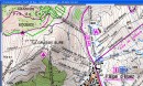
South-Africa, Topo 1:50K NGI
This map is the official topographic map at 1:50,000 of the South African national survey (National Geo-spatial information)
It consists of more than 1900 individual sheets and covers the entire country (not Swaziland and Lesotho). All sheets were recalibrated by us to correct scan distortion and to achieve the maximum possible accuracy of GPS, and then combined into a single seamless map in QBR-format for QuoVadis 6
You can freely and with high performance zoom and scroll in the map across the whole country.
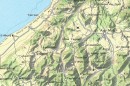
Included also are the SRTM3 elevation data for South Africa, so you can work with the map in the 3D modeas well.
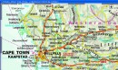
Further, the map scales 1:250,000 and 1:500,000 are also included as seamless maps with complete coverage (with Swaziland and Lesotho).
For each QuoVadis-user travelling offroad or outdoors in South Africa, this map is a "must-have". There is nothing better on the market. As a complement to this map, the routable road-map V13000 Tracks4Africa 2012 fits perfectly.
Lieferung: Download, optional "Sicherungskopie der aktuellen Bestellung" auf DVD/USB ohne Versandkosten
Delivery: Download, optional add item "Backup copy of your order" to receive order on DVD/USB, no shipping costs apply
It consists of more than 1900 individual sheets and covers the entire country (not Swaziland and Lesotho). All sheets were recalibrated by us to correct scan distortion and to achieve the maximum possible accuracy of GPS, and then combined into a single seamless map in QBR-format for QuoVadis 6
You can freely and with high performance zoom and scroll in the map across the whole country.
Included also are the SRTM3 elevation data for South Africa, so you can work with the map in the 3D modeas well.
Further, the map scales 1:250,000 and 1:500,000 are also included as seamless maps with complete coverage (with Swaziland and Lesotho).
For each QuoVadis-user travelling offroad or outdoors in South Africa, this map is a "must-have". There is nothing better on the market. As a complement to this map, the routable road-map V13000 Tracks4Africa 2012 fits perfectly.
Lieferung: Download, optional "Sicherungskopie der aktuellen Bestellung" auf DVD/USB ohne Versandkosten
Delivery: Download, optional add item "Backup copy of your order" to receive order on DVD/USB, no shipping costs apply